
Utah,
ranches, spurs and petroglyphs
around Torrey
In Moab, our tour reaches the easternmost point of our loop.
The visit therefore departs from there towards west.

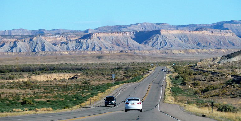
Utah, from Moab through the San Rafael Desert
The 191 leads first north, up to "Crescent Junction".
The direct asphalt line rush towards these mountains, "Christmas Ridge" and more to the left "Hatch Mesa", which seem close.
At 1750 m above sea level, they dominate more than 200 meters the lowest in the valley.
Yet we only reach them after 20 or 30 km seemingly endless : the relief slips away as advancing.
On these grey mountains, ribbed by erosion above Crescent Junction, is the site of release of uranium tailings, out of any population (it's said) transported from Moab by special train.
Then the road comes up against the relief and crosses the 70 which runs along it. Route 70 must be taken westward. Simplicity of the shortest route.
Eroded mountains compete in light watercolor nuances.

On the winding highway, a sign warns that no "service" (no gas station) is available for 100 miles (160 km).
If we continued on this one.
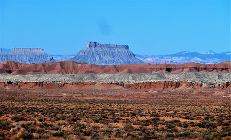
The oblique spurs rocks in the distance are the San Rafael Reef, remains of an old broken anticline, itself part of a large geological ensemble called the San Rafael Swell, very emaciated by erosion.


Crossing of the Green River would be made almost incognito, except greenery around its bed (irrigation areas).
Then just before passing the San Rafael river (valley below), which joins the Green River further south, we yaw to the south on Route 24.

... to approach the San Rafael desert. One more desert one might say ...
But this one offers such geographical analogies with the planet Mars that the Mars Desert Research Station has been established over there.

Nothing, no obstacle to the gaze that accommodates to infinity.
The vastness is bordered far away by long rectilinear chains of regular massifs of moderate altitude.
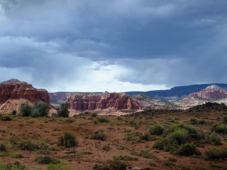
The effects of erosion on the geological layers again make up superb panoramas, soft capped reliefs, very powerful and high tables, mesas, like the "Factory Butte".

Immensity of plateaus and valleys, endless straight roads. Their course sometimes bends in long curves before returning to another straightness.
With the absence of a bus line or railway other than for ore, there is no salvation without a car.
Its use is facilitated by the cost of a liter of fuel, about half the price of ours in France.
But the car must be maintained, comfortable, able to navigate these huge spaces without breakdown. The speed is limited : never above 75 mph, most often 65 mph, and frequently 50 mph.
Dear compatriots who resist with the limitation to 80 km / h (about 50 mph) in our countryside, here, it's been like this for decades and the roads are much less twisty.
In the middle of the desert on the side of the road, a high hillock seems to be made of layers of worn rounded bricks, like the still standing vestige of a abandoned ruin of Tamanrasset.

Opposite, a cloud hat hangs on a table of layers ; somewhere over there is "Goblin Valley", because of countless small columns that evoke goblins.
But it would be vain to have seen everything.

Utah,
along the Fremont river
Soon here is the isolated hamlet of Hanksville. Sumptuous shows of erosion work continue to fascinate.
This is where the Fremont River meets with "Muddy Creek", to form the "Dirty Devil" River which flows downstream into Colorado.

Senior active american
In this very small, very authentic village, is only one grocery store.
Despite its ample size, it seems to be held only by a very alert, upright elderly lady, hollow face and bright smile, the archetype of those American retirees required to supplement their income with a late job.
She prepares with local products (lettuce, turkey meat…) an abundant sandwich that she takes the time to make with care for me.
Between the few shelves of this "General Store" crisscrosses a corpulent man, a little hideous, white complexion, smiling, that we believe at first disabled, eyes bulging like in the film " M" of Fritz Lang.
The only other customer we meet here, he comes to us and explain in French with accent that he is Mormon, and that he spent some time on a mission in the Strasbourg area.
Hence his practice of French, which he heard us speak.
Astonishing encounter in this isolated country.
Then the lady of the store delivers her sandwich with her natural empathy which wins our sympathy.
So that after these few moments, we leave with exchanges almost full of emotion, on "very happy to see you" mutual, warm and sincere.
Numerous are these seniors, necessarily very alert, serving tables in restaurants, driving buses while commenting on the landscape, providing hospitality in hotels, driving like at Lake Powell a boat...
In fact, a real institution.

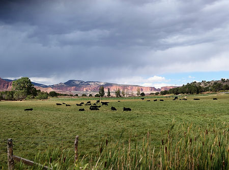
In the meadows of thick grass graze herds of black cows, at the foot of a mesa near of next small village, that of Caineville. On the ravines slopes, the edges remain sharp.
Here comes a region of cowboys.


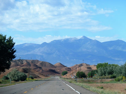
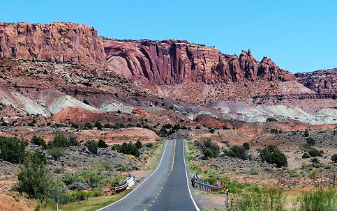
Soon rise the steep landforms of Capitol Reef Park.
The Fremont river in its bed that's becoming sunk, deploys its many nervous meanders, which are cut to the shortest by Route 24. A little upstream from Torrey, it is called the "Sulfur river" and still upstream towards the "Sand river" source.

Far from being a torrent, the river is calm. With the poplars that border it, it makes a bucolic and bountiful setting whose greenery harmonizes with the raw and intact ocher of the cliffs.

the Fremont river
the 24 Route
the cliff
poplars
Water, crannies, refuge from the harshness of the climate, nothing more was needed for this small region to be chosen by the ancient Amerindian populations, then by the Mormons to settle, even to prosper.
A prosperous ancient people
(information from the panels at the cliff bottom)
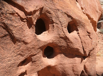
Numerous traces (objects, utensils, and petroglyphs) dating from the period 300 to 1300 prove that Native Americans made their home in this oasis of red rocks.
They are named the "Fremont" by Euro-American archaeologists (named after the river).
But current Native American tribes reject this name attributed to their ancestors, who lived there for 4000 years, although before the arrival of Europeans.
For the Hopis , they are the "Hisatsinom" (the people before) and for the Païutes, the "Wee Noonts" (the people who lived in the old days).
They cultivated, gathered, hunted, but were also potters, masons ... and had implemented a rudimentary irrigation system.
They stored the grain to face the rigors of the cold season. Their dwellings were cavities half-dug in the ground and the rock, covered with a green roof.
In addition to a well-marked spirituality, they lived prosperous enough to make jewelry, charms, pottery, basketwork, and above all to tell their life story with the petroglyphs engraved or painted at the foot of the cliff.
Their trace disappears after 1300, because of wars, drought, depletion of resources. They would have been assimilated to other tribes.
Rather, the Hopi believe that they migrated to the Center of the "Tuuwanasavi" Universe.
Contemplating petroglyphs without damaging the site is possible from a wooden pontoon which allows to walk along the cliff bottom gathering the most of these works.

Cousin artists distant, but close in inspiration, to those for example of the "Vallée des Merveilles" in the Mercantour, France.


Continuing on route 24 westward, the cliff face widens out, revealing a larger green valley, backed by a high red cliff.
There , on a fork is the hamlet called Fruita, mainly because of an old and rather large orchard created by the Mormons before the beginning of the 20th century.


The few houses and cabins are now hardly there other than to bear witness to the life of those pioneer times.
The US visitors are numerous, a bit here in the spirit of an old-fashioned fair.
The site is not lacking in grandeur, but what follows by continuing on the road "Scenic Drive" to the south is even more spectacular.
Mormons in Fruita and Fremont Origin
Like Native Americans before them, Mormons recognized the attractiveness and strengths of Fruita site.
" Having come there around 1880, they survive in total autonomy, building an irrigation system for the orchards (cherries, peaches, apples, etc.) that they have created ; the first tractors were not used until around 1940 and electricity only arrived in 1948. Storage of food, smoked meat, dried fruit, clothing, farm equipment, wooden houses, toys, everything was done on site ; and nothing was wasted ... ".
Fremont , the name of the river, but also the one that the Europeans attributed to the Native Americans of the origins, sounds French. We would gladly write Frémont with an accent.
This name was that of an explorer then politician and American general, John C. Frémont, whose father was a Quebec refugee Louis-René Frémont born in Quebec in 1768, and his great-grandfather a French from St Germain en Laye in France emigrated to Canada.
Utah,
trails at Capitol Reef
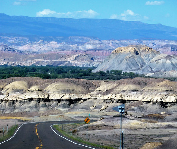
The diversity of colors in this constant ocher tone that is often cut by a layer of an almost immaculate white is remarkable and is available on all kinds of reliefs in plateaus or in eroded cones, often harmonizing with the short greenery of the valley bottom of the Fremont.

The dark sky which lines the background and the play of the rays of the sun underline the horizontal layers, in panoramas still different, magnificent and wild.
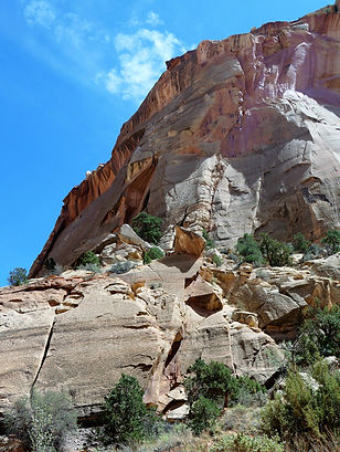
Almost greenish veins, pointed cones of whiteness, bistre boulders, the still paved road leads to another junction which this time on the left becomes a trail.

This is the road named "Capitol Gorge", which is a very spectacular long and winding parade, where sometimes the freshness of the colors of the rocks is that of the first days.

At the end of the trail, raising behind us a very dry ocher dust with our car which is not a 4x4, here is a parking lot which is also a dead end, and a starting point for hikes.
Nestled between ocher walls sculpted by the wind and sand, its walls are hollowed out like a part of Emmenthal, elsewhere more numerous like a face skin pockmarked by smallpox.
Here perhaps nest these desert reptiles from Lovecraft's world.
There, towards the top of the cliff, an arch has been named "Cassidy arch", from the name of the famous bandit "Butch cassidy" who would have taken refuge there ; he seems to have scoured the region of which other places also bear his name. You can only access this arch by a long hike from a high balcony that is said to be quite spectacular.

"Cassidy Arch"
"Butch Cassidy"
Born in 1886 in Circleville north of Bryce Canyon, he died in Bolivia around 1908, after a life of theft, looting and murder in a gang where he notably associated with "Sundance kid"..

What delicacy and what empathetic charm emerges from this face ...
Utah,
Torrey, a pretty village in the land of vigilant cowboys
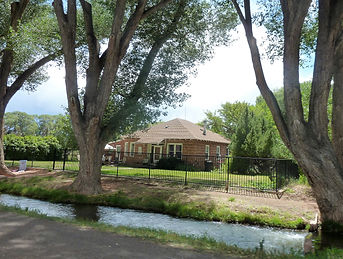
Here is finally the rider, prosperous and rather banal small village of Torrey. It stretches along Route 24, bordered by tall trees, especially old and gnarled cottonwoods, roots close to a modest river. no larger than a ditch, called "Torrey Canal" (its path has certainly been rectified).
This allows the irrigation of large pastures for cattle framed by barriers.

The pretty shady village stall around the small church and an old wooden school (the first public establishment), well preserved, a few large scattered houses and catch-all souvenir shops.


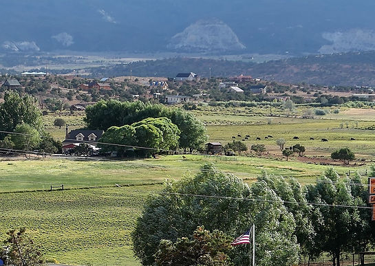
Away from the axis of the 24, houses quickly give way in a vast valley to the south, to large enclosures surrounded by white barriers, as many ranches, dominated further by a mountain range which rises.
On a sign in front of one of them, it can be read "get away" ; an owner too bothered by visitors certainly, and endowed with a keen sense of his very private property.

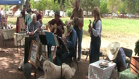
The local producers' market, a modest row of stalls spaced over ... 50 meters, is held every day between 4 p.m. and 6 p.m., along Route 24 in the village center.

A small "country" orchestra with authentic old inhabitants in traditional clothes, sings and play, with for some a banjo, a violin.
The barely audible repertoire seems to belong to the local tradition and everyone is doing their part with the jaded and good-natured smile of those who have rehearsed for a long time.

Elsewhere a young, bearded and very cordial producer sells fresh "pasture-raised" eggs…”. Intrigued, I discuss with him about his eggs from hens that run in the grass (not eggs, chickens), naturally organic.
In view of an upcoming election, the large-format portrait of the candidate sheriff (does he have any challengers?) throne in full mustache, trumpesque blond hair, with a statue of a buffalo at the back.
Local solidarity relies on the vigilance of all to ensure safety, just in case. A very explicit official sign invites you to immediately report any behavior deemed suspicious or abnormal : "any questionable person or activity must be reported immediately to the sheriff's office".


In front of the market on the other side of the road after having crossed the stream, in an old house that he has totally and patiently restored respecting the quality of materials and the original architecture, an old man, open and dignified sells local handicrafts, and small, fairly original and beautifully crafted works of art.
Local conversations between the people of the village who know or recognize each other are going well, while on the road humming huge pick-ups and two riders (the only ones we will see), stunned by the heads and spurs to boots.

Our hotel, perched on a small plateau where the evening wind is harsh, barely away from the village, is full of local symbols specific to cowboys and ranches, horses and the conquest of the west.
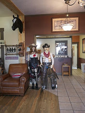


So that in addition to the very "western" rooms (bedside tables mounted in horseshoes ...), it also offers to live in well reconstructed carts - in any case seen from the outside - from the time of the conquest, air conditioning in addition. Even the hotel's very name, “Broken Spur Inn”, expresses the context.

Finally however, perhaps we owe the omnipresence of the much supported representation "western" to the almost total absence of others more direct heritages and witnesses.
But authenticity wouln't be complete without these superb and gleaming Harley Davidson.

